|
North Carolina Outer Banks
Albemarle Sound and Pamlico Sound
The Civil War was fought
in many places across the southern landscape, but perhaps no region held as much importance to the Union's Anaconda Plan as eastern North Carolina. Control of the sounds and rivers of North Carolina was vital to cutting off the Confederacy's southern supply routes to Virginia. As the Federal government tightened its blockade, rapidly raising the number of its
ships from 42 in 1861 to 671 in 1864, it viewed "the necessity of possessing the North Carolina sounds as well as its Outer
Banks."
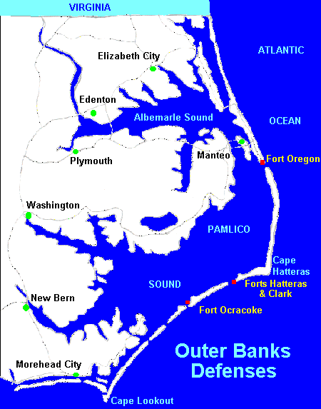
| North Carolina Outer Banks and Sounds Map |
|
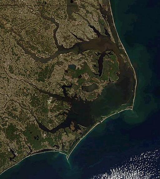
| Satellite Photo of Albemarle Sound and Pamlico Sound |
| Civil War Map of NC Sounds and Outer Banks |
|
| Civil War Map of North Carolina Albemarle Sound, Pamlico Sound, and Outer Banks |
(Left) Map of Civil War era North Carolina coast with forts and batteries located on
the outer banks. (Right) Map of North Carolina Outer Banks: A long string of narrow barrier islands off the coast of North
Carolina separating the Atlantic Ocean (east) from Currituck and Albemarle Sounds (north) and Pamlico Sound (south). Orbital
photo courtesy NASA.
The Outer Banks is a 200-mile (320-km) long string of narrow barrier islands off the coast of North Carolina, beginning in southeastern
corner of Virginia Beach on the east coast of the United States. They cover approximately half the northern North Carolina
coastline, separating the Currituck Sound, Albemarle Sound and Pamlico Sound from the Atlantic Ocean. (See also Torpedo Alley.)
The Outer Banks is a series of islands: from north to south —
Bodie Island, Roanoke Island, Hatteras Island, and Ocracoke Island. The northern part of the Outer Banks, from Oregon Inlet
northward, is usually considered part of the North American mainland, although it is technically separated by the Intracoastal
Waterway, which passes through the Great Dismal Swamp occupying much of the mainland west of the Outer Banks.
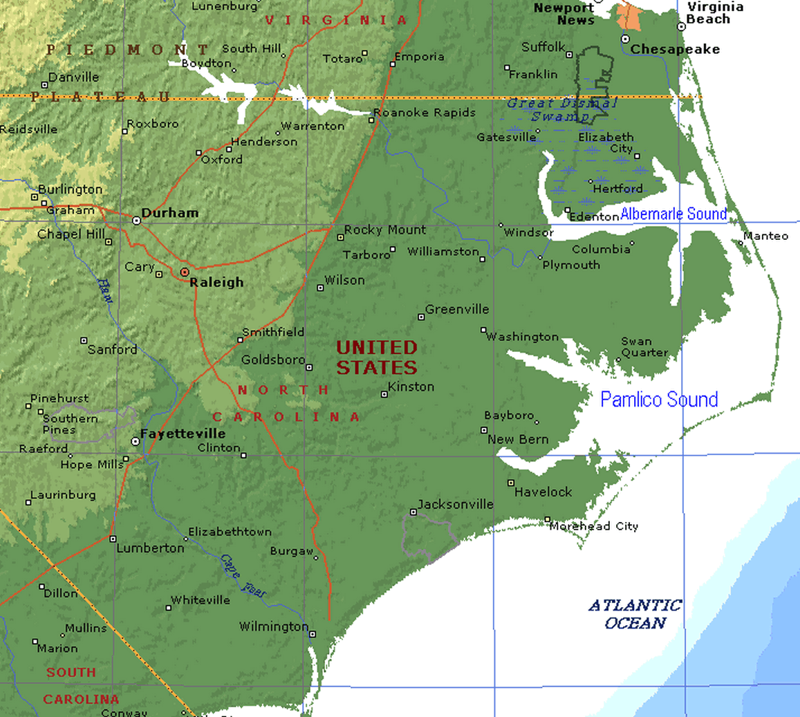
| Terrain Map of the Albemarle and Pamlico Sounds |
|
| Terrain Map of North Carolina Outer Banks, Albemarle Sound and Pamlico Sound |
On the
Outer Banks, first settlers were fishermen or wreckers. Known the world-over as the Graveyard of the Atlantic, the waters
off the Outer Banks are littered with the bones of thousands of ships that have met their fate. Many Outer banks' home
were built from the lumber salvaged from shipwrecks.
| Albemarle Sound and Pamlico Sound, North Carolina |
|
| Satellite Image (with Map) of North Carolina Terrain |
| North Carolina Outer Banks Civil War Map |
|
| Albemarle Sound and Pamlico Sound Civil War Map |
No large-scale battles were
fought in the Albemarle Sound, but dozens of small strategic battles
were waged for control of the region. The first strategic move on the region arrived with General Ambrose Burnside's
Union expedition, a.k.a. Burnside's North Carolina Expedition, to capture Hatteras Inlet in late 1861. After a brief sea and land battle, the two Confederate forts that controlled
inlet access fell into Union hands. From there, Burnside quickly advanced up Pamlico Sound and captured Roanoke Island. Now, Burnside had a base of operations from which to conduct a systematic conquest of the northeastern and central part
of the coast.
Although Roanoke Island
was the site of one of the largest battles in the state, today there is no physical evidence of the fight. The fall of Roanoke Island, however, is remembered for another notable reason: it became a haven for escaped
and freed slaves who sought the protection of the occupying Union army. By 1863, nearly 3,000 freedman had settled on the
island and established the first Freedman's Colony of the war.
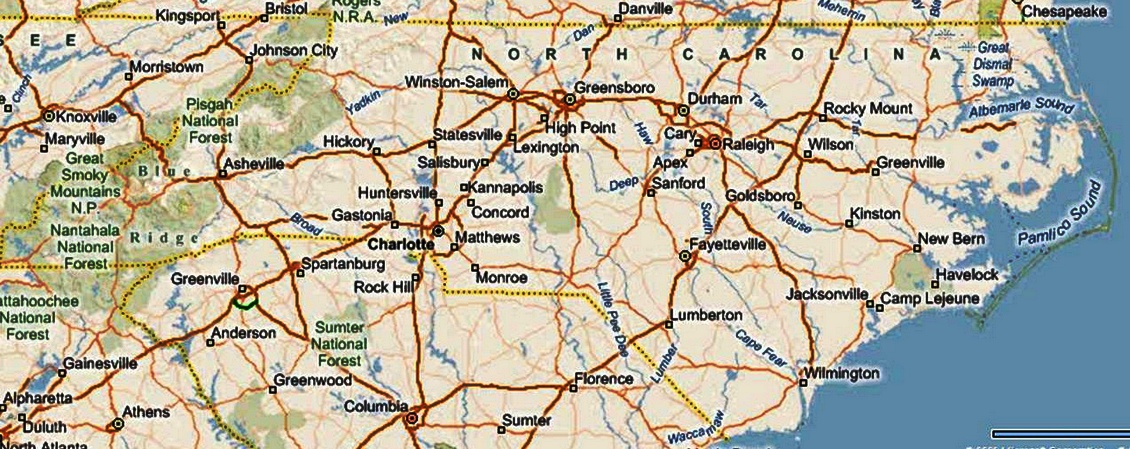
| High Resolution Satellite Map of North Carolina |
|
| High Resolution Satellite Map of North Carolina. Courtesy Bing Maps 3D. |
(About) High Resolution Satellite Image of North Carolina. This satellite image
of North Carolina contains a map with principal cities and highways. Try to locate the three regions of North Carolina --
Coastal Plains, Piedmont, and Mountains -- by its terrain. The coast hosts two large sounds known as Albemarle
and Pamlico, and they are protected by a series or string of barrier islands known as the Outer Banks.
| Satellite View of North Carolina by Bing |
|
| Bing Satellite Photo of North Carolina |
The Wilmington & Weldon Railroad ran between Wilmington, NC, and Richmond
and soon became one of the most important supply routes for the Confederacy. Thus, Burnside launched a series assaults up
the Albemarle Sound in an attempt to capture the line and control the waterways. The undersupplied Confederates defended the towns as
best they could with a motley collection of armed boats called the "mosquito fleet." Elizabeth City was first to fall, then Edenton with barely a shot fired. The Federals then occupied
Plymouth, during the Operations against Plymouth, which cinched their control of the Albemarle Sound.
Plymouth changed hands several times
during the war and was the focal point of much of the fighting in the Albemarle
region. The Confederates had succeeded in building a formidable ironclad, the CSS Albemarle, which prevented Union ships from capturing the town via the Roanoke River. Finally, on
October 27th, 1864, in one of the most daring maneuvers of the war, Federal soldiers slipped over to the CSS Albemarle under
cover of night, planted an explosive using an improvised torpedo boat, and sent the ironclad to the bottom of the river.
| North Carolina Outer Banks Defense System |

|
| North Carolina Outer Banks Civil War Defense System |
However, Union forays up the Chowan and Roanoke
Rivers were not as successful, thanks to heavy defensive positions such as Fort Branch, which commanded the Roanoke River above Williamston from a high bluff. The Wilmington-Weldon Railroad remained in operation
until the end of the war.
Meanwhile, federal troops from recently captured New Bern launched an attack on Washington in March 1862, which they
captured after a fiery fight. The town remained in federal hands despite several attempts at recapture by the Confederates.
Finally, in April 1864, the Confederates launched a final attack which was successful--but only after departing Union troops
burned most of the town. (North Carolina Coast and the American Civil War: Operations,
Campaigns, and Expeditions.)
Perhaps the most historically valuable Civil
War site is located in 300 feet of water off Caper Hatteras; that is where the
crew of the USS Monitor met their fate on a stormy New Year's Eve in 1862. For 100 years, her resting place remained
a mystery. Then, in 1973, a Duke University
research team located her lying upside down on the sandy bottom 190 miles southeast of Cape Hatteras. The site was placed on the National
Register of Historic Places in 1975.
The North Carolina Coastal Region was host to the English
Roanoke Colony—where the first person of English descent, Virginia Dare, was born on American soil—but all had
vanished from Roanoke Island in 1587. The Lost Colony, written and performed to commemorate the original colonists, is the
longest running outdoor drama in the United States and its theater acts as a cultural focal point for much of the Outer Banks.
Although Black Beard met his fate off the coast, so did many merchant ships during WWII in what is now known as Torpedo
Alley. The treacherous seas off the Outer Banks and
the large number of shipwrecks that have occurred there have given these seas the nickname Graveyard of the Atlantic. The North Carolina coast also witnessed the Wright brothers' first
flight on the Outer Banks on December 17, 1903, at Kill Devil Hills near the seafront town of Kitty Hawk. But to those
who live and vacation in the region, it is truly a seaside paradise.
(Sources and related reading below.)
Recommended Reading: The Civil War in the Carolinas
(Hardcover). Description: Dan Morrill relates the experience
of two quite different states bound together in the defense of the Confederacy, using letters, diaries, memoirs, and reports.
He shows how the innovative operations of the Union army and navy along the coast and
in the bays and rivers of the Carolinas affected the general course of the war as well as
the daily lives of all Carolinians. He demonstrates the "total war" for North
Carolina's vital coastal railroads and ports. In the latter part of the war, he describes
how Sherman's operation cut out the heart of the last stronghold
of the South. Continued below...
The author
offers fascinating sketches of major and minor personalities, including the new president and state governors, Generals Lee,
Beauregard, Pickett, Sherman, D.H. Hill, and Joseph E. Johnston. Rebels and abolitionists, pacifists and unionists, slaves
and freed men and women, all influential, all placed in their context with clear-eyed precision. If he were wielding a needle
instead of a pen, his tapestry would offer us a complete picture of a people at war. Midwest Book Review: The Civil War in the Carolinas by civil war expert and historian
Dan Morrill (History Department, University of North Carolina at Charlotte, and Director of the Charlotte-Mecklenburg Historical
Society) is a dramatically presented and extensively researched survey and analysis of the impact the American Civil War had
upon the states of North Carolina and South Carolina, and the people who called these states their home. A meticulous, scholarly,
and thoroughly engaging examination of the details of history and the sweeping change that the war wrought for everyone, The
Civil War In The Carolinas is a welcome and informative addition to American Civil War Studies reference collections.
Advance to:
Recommended Reading: Ironclads and Columbiads: The Coast (The Civil War in North Carolina) (456 pages). Description: Ironclads and Columbiads covers some of the most important battles and campaigns in
the state. In January 1862, Union forces began in earnest to occupy crucial points on the North Carolina coast. Within six months, Union army and naval forces effectively controlled
coastal North Carolina from the Virginia line south to present-day
Morehead City.
Union setbacks in Virginia, however, led to the withdrawal of many federal soldiers from North Carolina, leaving only enough
Union troops to hold a few coastal strongholds—the vital ports and railroad junctions. The South during the Civil War,
moreover, hotly contested the North’s ability to maintain its grip on these key coastal strongholds.
Recommended Reading: The
Civil War in Coastal North Carolina (175 pages) (North Carolina Division of Archives and History). Description: From the drama of blockade-running to graphic descriptions of battles
on the state's islands and sounds, this book portrays the explosive events that took place in North Carolina's
coastal region during the Civil War. Topics discussed include the strategic importance of coastal North Carolina, Federal occupation of coastal areas, blockade-running, and the impact of
war on civilians along the Tar Heel coast.
Recommended Reading: The
Civil War on the Outer Banks: A History of the Late Rebellion Along the Coast of North Carolina from Carteret to Currituck
With Comments on Prewar Conditions and an Account of (251 pages). Description: The ports at Beaufort, Wilmington, New Bern and Ocracoke, part of the Outer Banks (a chain
of barrier islands that sweeps down the North Carolina coast from the Virginia Capes to Oregon Inlet), were strategically
vital for the import of war materiel and the export of cash producing crops. From official records, contemporary newspaper
accounts, personal journals of the soldiers, and many unpublished manuscripts and memoirs, this
is a full accounting of the Civil War along the North Carolina
coast.
Recommended Reading: Storm
over Carolina: The Confederate Navy's Struggle for Eastern North Carolina. Description: The struggle for control of the eastern
waters of North Carolina during the War Between the States
was a bitter, painful, and sometimes humiliating one for the Confederate navy. No better example exists of the classic adage,
"Too little, too late." Burdened by the lack of adequate warships, construction facilities, and even ammunition, the
South's naval arm fought bravely and even recklessly to stem the tide of the Federal invasion of North
Carolina from the raging Atlantic. Storm
Over Carolina is the account of the Southern navy's struggle in North
Carolina waters and it is a saga of crushing defeats interspersed with moments of brilliant and even
spectacular victories. It is also the story of dogged Southern determination and incredible perseverance in the face
of overwhelming odds. Continued below...
For most of
the Civil War, the navigable portions of the Roanoke, Tar, Neuse, Chowan, and Pasquotank rivers were
occupied by Federal forces. The Albemarle and Pamlico sounds, as well as most of the coastal towns and counties, were also
under Union control. With the building of the river ironclads, the Confederate navy at last could strike a telling blow against
the invaders, but they were slowly overtaken by events elsewhere. With the war grinding to a close, the last Confederate vessel
in North Carolina waters was destroyed. William T. Sherman
was approaching from the south, Wilmington was lost, and the
Confederacy reeled as if from a mortal blow. For the Confederate navy, and even more so for the besieged citizens of eastern
North Carolina, these were stormy days indeed. Storm Over Carolina describes their story, their struggle, their history.
Recommended
Reading: American Civil
War Fortifications (1): Coastal brick and stone forts (Fortress). Description: The 50 years before the American Civil War saw a boom in the construction of coastal forts
in the United States of America. These
stone and brick forts stretched from New England to the Florida Keys, and as far as the Mississippi River.
At the start of the war some were located in the secessionist states, and many fell into Confederate hands. Although a handful
of key sites remained in Union hands throughout the war, the remainder had to be won back through bombardment or assault.
This book examines the design, construction and operational history of those fortifications, such as Fort
Sumter, Fort Morgan
and Fort Pulaski,
which played a crucial part in the course of the Civil War.
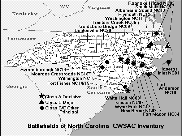
North Carolina Outer Banks: Albemarle Sound and Pamlico Sound, List of North Carolina Forts, Batteries,
Battles, Battlefields, Civil War Maps, North Carolina Coast American Civil War History, Facts, Details.
Sources: Historic Albemarle Tour, Inc., historicalbemarletour.org;
Official Records of the Union and Confederate Armies; North Carolina Office of Archives and History; Geology.com; Diary of
Gen. Winfield Scott; Map of Albemarle and Pamlico Sounds courtesy Microsoft MapPoint; Map of North Carolina courtesy Microsoft
Virtual Earth; Satellite View of North Carolina courtesy Microsoft Virtual Earth (3D).
|