|
North Carolina
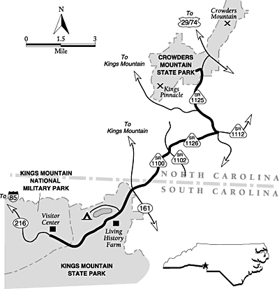
Crowders Mountain and Kings Mountain Scenic Driving Route
Map
| North Carolina: Crowders and Kings Mountain Map |
|
| Courtesy weather.com |
General description: A short, paved 10-mile route
including a Revolutionary War battlefield, two state parks, a living history farm just over the border in South Carolina,
and prominent Piedmont peaks.
Location: South-central North Carolina and adjacent South Carolina.
The drive starts in South Carolina at Kings Mountain National Military Park. Take Exit 2 from I-85 a little less than 40 miles
west of Charlotte, and follow the signs on SC 216 about 4.5 miles to the military park visitor center.
Drive route name/numbers: SC 216, SR 1100/Battleground Road,
SR 1102/Unity Church Road, SR 1126/Lewis Road, SR 1112/Lewis Road, SR 1125/Sparrow Springs Road, State Park Lane.
Travel season: Year-round.
Special attractions: Kings Mountain National Military Park (Battle
of Kings Mountain Battlefield), Kings Mountain State Park, Crowders Mountain State Park, historic battlefield, Living History
Farm, hiking, fishing, swimming, rock climbing, boating, fall colors, scenic views.
Camping: Kings Mountain State Park has a large campground. Crowders
Mountain State Park has primitive backpacking campsites only.
Services: All services are available in nearby Gastonia and Kings
Mountain.
Nearby attractions: South Mountains State Park, James Polk Memorial
State Historic Site, Reed Gold Mine State Historic Site, Duke Power State Park, Cowpens National Battlefield.
The drive: This short drive is notable for its connection
to Revolutionary War history. Many people tend to think of places like Lexington, Concord, Philadelphia, Boston, or Yorktown
when they think of the battle for American independence. However, battles in North and South Carolina were critical to the
ultimate defeat of the British. The drive begins at Kings Mountain National Military Park, just across the South Carolina
border. The park is an excellent launching point for a journey into the Carolina past.
In 1780, British general Charles Cornwallis ordered Major Patrick Ferguson,
a Scotsman, to scour the South Carolina countryside and build a strong Loyalist militia. Within days of moving into the upcountry,
Ferguson had recruited several thousand Carolinians who were loyal to the Crown. With this new army, he proceeded to hunt
down and punish colonial rebels who resisted British authority. A nasty, violent guerrilla war ensued.
Until that time, the frontiersmen who had settled these rugged Appalachian
Mountains had been unaffected by the war. In their remote settlements, they had been virtually independent of any kind of
authority. Most were of Scotch-Irish descent, but other families hailed from Wales, England, France, and Germany. Once the
war moved into their backyard, these independent settlers resisted fiercely. During the summer of 1780, militias of these
"over-mountain" men engaged Ferguson's loyalists in small but fierce battles.
In August of that year, Ferguson's Tory forces set up camp at Gilbert Town,
a tiny outpost at the foot of the mountains. Ferguson then sent an ultimatum to the over-mountain men. The message was this:
if the rebels did not desist from their opposition, Ferguson would cross the mountains, hang their leaders, and lay their
country waste "with fire and sword." Naturally, these scrappy rebels didn't take kindly to the threat. On September 25, they
gathered at Sycamore Shoals on the Watauga River in Tennessee under the leadership of Colonels Isaac Shelby, Charles McDowell,
John Sevier, and William Campbell. The next day, they began a difficult 5-day march over the snowy mountains to Quaker Meadows
where 350 more men joined them. The ragged army then marched toward Gilbert Town.
Ferguson learned of their approach and retreated while he called for reinforcements.
On the afternoon of October 6 he reached Kings Mountain, a long narrow ridge that rises 60 feet above the rolling country
at its base. With the advantage of height, Ferguson and his 1,100 men set up camp. When the over-mountain men learned that
Ferguson had fled, they resolved to pursue him. They pushed through a night and day of pouring rain to arrive at Kings Mountain.
There they took a horseshoe-shaped position around the mountain's base. Ferguson was taken by surprise, and sustained fighting
soon commenced. The rebel Americans twice advanced up the mountain before being forced to retreat under withering musket fire
and bayonet charges. Although the British position gave them the advantage, the slopes were densely wooded and offered the
rebels good cover. To one soldier, the mountain seemed "volcanic" since, as he later wrote, "there flashed along its summit,
and around its base, and up its sides, one long sulfurous blaze."
The rebel, or Whig, army finally achieved the summit after about an hour of
bloody fighting. Using a whistle and a horse, Ferguson raced around the smoky battlefield urging on his men until rebel bullets
found him. Leaning against a tree, he died; his subordinate then raised a white flag to surrender. But the rebel leaders could
not immediately gain control of their independent men, who continued to shoot down terrified Loyalists. Ironically, the only
British soldier to die here was Ferguson; all the other dead were Loyalists or Whigs from the colonies. The toll was high:
225 Carolina Loyalists dead and 163 wounded; 28 over-mountain men slain and 62 wounded.
One soldier recalled the first night after the battle: "The groans of the
wounded and dying on the mountain were truly affecting -- begging piteously for a little water; but in the hurry, confusion,
and exhaustion of the Whigs, these cries, when emanating from the Tories, were little heeded." The next day was little better
for the Loyalist captives. Those who had not died fighting were marched toward Hillsborough, North Carolina, and the American
army there. On the journey, the rebels' fury led them to beat their charges and hack at them with swords. A week later, nine
of the Tories were hanged after a wartime trial.
The over-mountain men drifted back to their villages and homesteads, but this
Carolina battle greatly raised Whig spirits and hurt Loyalist recruiting. Cornwallis retreated while the American Continental
Army gained strength. On January 17, 1781, the Americans defeated a superior force of regular British troops at Cowpens, about
30 miles west of Kings Mountain. On March 15, General Nathanael Greene led his American troops against Cornwallis's main army
at Guilford Courthouse in North Carolina. Though Greene's troops were forced to withdraw, the Americans inflicted heavy losses
on the British. Greene proceeded to retake South Carolina while Cornwallis spent the summer fighting a string of unproductive
battles. The British leader finally surrendered at Yorktown, Virginia, on October 19, 1781. His surrender effectively ended
the Revolutionary War.
Start your visit at Kings Mountain by viewing the interpretive exhibits in
the visitor center, which give more details about the battle described above. Then take the paved trail that leads through
the battlefield itself. Monuments and markers commemorate the crucial sites along the trail. Birds twittering in the trees
give no hint of the bloodshed that occurred here more than 200 years ago. If you are interested in Revolutionary War history,
be sure to visit Cowpens National Battlefield only about 30 miles west. Guilford Courthouse National Military Park is quite
a bit farther away, on the edge of Greensboro, but it, too, is particularly worthwhile.
From the rich history at Kings Mountain National Military Park, the scenic
drive heads southeast toward Kings Mountain State Park. After passing through lush woods, you enter the state park in 0.9
mile. Be sure to stop in at the Living History Farm on the right in another 1.7 miles. Park staff have reconstructed and restored
a 19th-century farm, complete with houses, barns, corrals, and other structures. Workers re-enact activities from those times,
giving visitors a glimpse of pioneer life. Just down the road is the main state park entrance, with access roads to many of
the park's facilities, including a large campground, lake, store, and picnic area. You can hike, ride horses, fish, boat,
camp, or even play miniature golf here. From the state park center, continue down the highway 0.9 mile to the park boundary
at SC 161. Continue straight across the intersection on Battleground Road and enter North Carolina in 0.8 mile.
The road now becomes SR 1100/Battleground Road. Turn left in 1 mile on SR
1102/Unity Church Road, then almost immediately turn right onto SR 1126/Lewis Road. Follow Lewis Road 1.6 miles, then turn
left onto SR 1125/Sparrow Springs Road. Turn left again in 2.3 miles onto State Park Lane, which enters Crowders Mountain
State Park, the ending point of the drive. The North Carolina Atlas & Gazetteer can help you find your way through some
of these back roads, but it names some of the roads incorrectly. The directions and road names in this book are accurate.
Two peaks in this state park, Crowders Mountain and Kings Pinnacle, are monadnocks
or remnants of ancient mountain ranges that have eroded away. A mighty mountain range that was an outlier of the Appalachians
once ran through here, but millions of years of erosion have made it disappear in most places. Only the durable quartzite-kyanite
core of the range remains. The two peaks rise about 800 feet above the gently rolling Piedmont; Kings Pinnacle is the highest,
reaching an elevation of 1,705 feet. Although Crowders Mountain is not quite as high, it has a more impressive band of cliffs.
Crowders Mountain was named for Ulrich Crowder, a German who purchased land here in 1789. Gold was discovered east of Charlotte
in 1799, leading to a minor gold rush in the area. Many mines and claims were developed over the following years. In 1970,
miners hoped to strip-mine Crowders Mountain for kyanite. The Gaston County Conservation Society was established to push for
protection of this important local landmark as a state park. After much negotiation and many complicated transactions to acquire
more than 100 parcels of land, the state park opened in 1974.
To really see Crowders Mountain State Park, you have to get out of your car
and don your hiking boots. Moderately strenuous trails lead to the summits of both mountains, giving you eyeball-to-eyeball
looks at vultures riding the thermals over the peaks. The lush, green Piedmont stretches out in all directions below, marked
with highways, homes, and factories. Not surprisingly, the park's cliffs of durable rock attract climbers. The park allows
climbing in certain areas only; be sure to check in at the park office before heading for the cliffs.
Although the peak trails are relatively strenuous, the trail that circles
the park lake is quite easy. You can always cast a line for bass in the lake, or relax and grill a steak at the picnic area
to end your drive.
Credit: weather.com
(visit weather.com for all your weather and travel needs); Adapted from the FalconGuide Scenic Driving North Carolina
by Laurence Parent.
Recommended Reading: The
Battle of Kings Mountain: Eyewitness Accounts. Description: "In the fall of the year one
thousand seven hundred and eighty, when the American cause wore a very gloomy aspect in the Southern States, Colonels Arthur
and William Campbell, hearing of the advance of Colonel Ferguson along the mountains in the State of North Carolina... formed a plan to intercept him." -Ensign Robert Campbell. Continued below…
On October 7, 1780, American Patriot
and Loyalist soldiers (those loyal to both British crown and cause) battled each other at Kings Mountain,
near the border of North and South Carolina. With over one
hundred eyewitness accounts, this collection of participant statements from men of both sides includes letters and statements
in their original form-the soldiers' own words- unedited and unabridged. Rife with previously unpublished details of this
historic turning point in the American Revolution, these accounts expose the dramatic happenings of the battle, including
new perspectives on the debate over Patriot Colonel William Campbell's bravery during the fight. Robert M. Dunkerly's work
is an invaluable resource to historians studying the flow of combat, genealogists tracing their ancestors and anyone interested
in Kings Mountain
and the Southern Campaign. “[The] accounts from both sides allow balance, fairness, objectivity, and historical
context that is rarely displayed in the study of warfare.”
Recommended
Reading: Scenic Driving North
Carolina,
2nd, by Laurence Parent (Scenic Driving Series). Description: Pack up the car and enjoy
thirty drives through some of the most spectacular scenery in the Tar Heel State. This indispensable highway companion maps
out trips for exploring scenic byways and side roads, from the deep forests and breathtaking views of the Blue Ridge Parkway
to the majestic lighthouses and historic villages of the Outer Banks, from the lush rolling country of the Piedmont to the
rugged terrain of the Appalachian Mountains. Continued below…
Inside you'll
find: Itineraries ranging from 10 miles to more than 115 miles in length; Route maps for each drive; Where to find treasures
such as windswept dunes, mountain streams, magnificent fall colors, roaring waterfalls, and local wildlife; Historical information
and suggested side trips; Tips on camping, travel services, and best driving seasons. About the Author: Laurence Parent is
a freelance photographer and writer specializing in landscape, travel, and nature subjects. He has written twenty-one books,
including seven FalconGuides. He resides in Wimberley,
Texas.
Recommended Viewing: The History Channel Presents The Revolution (A&E) (600 minutes). Review: They came of age in a new world amid intoxicating and innovative
ideas about human and civil rights diverse economic systems and self-government. In a few short years these men and women
would transform themselves into architects of the future through the building of a new nation – “a nation unlike
any before.” From the roots of the rebellion and the signing of the Declaration of Independence to victory on the battlefield
at Yorktown
and the adoption of The United States Constitution, THE REVOLUTION tells the remarkable story of this pivotal era in history.
Venturing beyond the conventional list of generals and politicians, THE HISTORY CHANNEL® introduces the full range of individuals
who helped shape this great conflict including some of the war’s most influential unsung heroes. Continued below...
Through sweeping cinematic recreations intimate biographical investigations and provocative political military
and economic analysis the historic ideas and themes that transformed treasonous acts against the British into noble acts of
courage both on and off the battlefield come to life in this dramatic and captivating program. This
TEN HOUR DVD Features: History in the Making: The Revolution Behind-the-Scenes Featurette; Interactive Menus;
Scene Selections.
Recommended Viewing:
The American Revolution (History
Channel) (482 minutes). Description: Revisit the birth
of a nation in this truly definitive look at America's fight for independence and
its world-changing rise to glory. The American Revolution features ten powerful documentaries--more than eight hours of essential
programming by THE HISTORY CHANNEL® and A&E on DVD for the first time. From the Declaration of Independence to the Treaty
of Paris, these are the stories and events surrounding the remarkable achievements of heroic individuals seized by the epic
forces of history. Hear the words of the founding fathers and other key figures, as read by leading actors such as Kelsey
Grammar (TV’s Frasier) and Michael Learned (TV’s The Waltons). Continued below...
Thrilling re-enactments of great battles, compelling period images, rare archival material, and commentary
by leading historians bring the past vividly alive. Between Bunker Hill and Yorktown, from Ben Franklin's masterful diplomacy to Benedict Arnold's deceit and tragedy,
The American Revolution presents a sweeping canvas of historical programming at its comprehensive best.
Recommended Reading: The Tar
Heel State: A History of North Carolina (Hardcover). Description: The Tar Heel State:
A History of North Carolina constitutes the most comprehensive and inclusive single-volume chronicle of the state’s
storied past to date, culminating with an attentive look at recent events that have transformed North Carolina into a southern megastate. Integrating tales of famous pioneers, statesmen,
soldiers, farmers, captains of industry, activists, and community leaders with more marginalized voices, including those of
Native Americans, African Americans, and women, Milton Ready gives readers a view of North Carolina that encompasses perspectives
and personalities from the coast, "tobacco road," the Piedmont, and the mountains in this sweeping history of the Tar Heel
State. The first such volume in more than two decades, Ready’s work offers a distinctive view of the state’s history
built from myriad stories and episodes. The Tar Heel State is enhanced by one hundred and ninety illustrations and five maps.
Continued below...
Ready begins
with a study of the state’s geography and then invites readers to revisit dramatic struggles of the American Revolution
and Civil War, the early history of Cherokees, the impact of slavery as an institution, the rise of industrial mills, and
the changes wrought by modern information-based technologies since 1970. Mixing spirited anecdotes and illustrative statistics,
Ready describes the rich Native American culture found by John White in 1585, the chartered chaos of North Carolina’s
proprietary settlement, and the chronic distrust of government that grew out of settlement patterns and the colony’s
early political economy. He challenges the perception of relaxed intellectualism attributed to the "Rip van Winkle" state,
the notion that slavery was a relatively benign institution in North Carolina,
and the commonly accepted interpretation of Reconstruction in the state. Ready also discusses how the woman suffrage movement
pushed North Carolina into a hesitant twentieth-century
progressivism. In perhaps his most significant contribution to North Carolina’s
historical record, Ready continues his narrative past the benchmark of World War II and into the twenty-first century. From
the civil rights struggle to the building of research triangles, triads, and parks, Ready recounts the events that have fueled
North Carolina’s accelerated development in recent years and the many challenges that have accompanied such rapid growth,
especially those of population change and environmental degradation.
Recommended Reading: Encyclopedia of North Carolina (Hardcover:
1328 pages) (The University of North Carolina Press). Description: The first single-volume reference to the events, institutions, and cultural forces that have defined
the state, the Encyclopedia of North Carolina is a landmark publication that will serve those who love and live in North Carolina for generations to come. Editor William S. Powell, whom
the Raleigh News & Observer described as a "living repository of information on all things North Carolinian," spent fifteen
years developing this volume. With contributions by more than 550 volunteer writers—including scholars, librarians,
journalists, and many others—it is a true "people's encyclopedia" of North
Carolina. Continued below...
The volume
includes more than 2,000 entries, presented alphabetically, consisting of longer essays on major subjects, briefer entries,
and short summaries and definitions. Most entries include suggestions for further reading. Centered on history and the humanities,
topics covered include agriculture; arts and architecture; business and industry; the Civil War; culture and customs; education;
geography; geology, mining, and archaeology; government, politics, and law; media; medicine, science, and technology; military
history; natural environment; organizations, clubs, and foundations; people, languages, and immigration; places and historic
preservation; precolonial and colonial history; recreation and tourism; religion; and transportation. An informative and engaging
compendium, the Encyclopedia of North Carolina is abundantly illustrated with 400 photographs and maps. It is both a celebration
and a gift—from the citizens of North Carolina, to the citizens of North Carolina.
"Truly an exhaustive and exciting view of every aspect of the Old
North State!”
|