|
North Carolina Blue Ridge Parkway Map
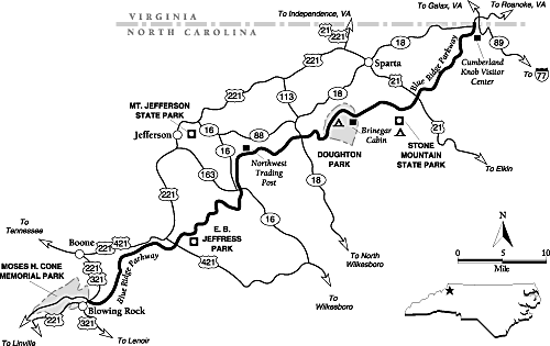
Virginia Line to Blowing Rock
| North Carolina: Blue Ridge Parkway North Map |
|
| Courtesy weather.com |
General description: A 75-mile section of the paved
recreational Blue Ridge Parkway, which follows the scenic crest of the Blue Ridge Mountains from the Virginia state line to
Blowing Rock.
Location: Northwest North Carolina. The drive starts where the
Blue Ridge Parkway enters the state about 17 miles west of Mount Airy.
Drive route name: Blue Ridge Parkway.
Travel season: Year-round; best season is April through October.
Special attractions: Cumberland Knob, Brinegar Cabin, Doughton
Park, Northwest Trading Post, E. B. Jeffress Park, Boone's Trace, Blowing Rock, hiking, scenic views, fall colors.
Camping: The National Park Service maintains a campground at
Doughton Park and at Julian Price Memorial Park a short distance south of Blowing Rock on the parkway. Nearby Stone Mountain
State Park also has a campground.
Services: Gas, food, and lodging are located on the parkway itself
at Doughton Park. Towns near the parkway, such as Sparta, Blowing Rock, and Boone, all have visitor services.
Nearby attractions: Stone Mountain State Park, New River State
Park, Mount Jefferson State Park, ski areas near Boone, Tweetsie Railroad, sections of the parkway to the north and south.
The drive: This is the northern section of the Blue
Ridge Parkway within North Carolina from the Virginia state line to Blowing Rock. The well-known scenic route was designed
as a recreational road along the crest of the Blue Ridge and other mountains of the Appalachian chain. Hence there is little
commercial truck traffic and few business establishments along the parkway itself. The road passes through a seemingly endless
array of deep forests, pastoral fields, and breathtaking views. Historic sites, hiking trails, and numerous overlooks break
up the trip. Though the parkway is hardly undiscovered, it is still one of the premier touring routes of the eastern United
States.
The Blue Ridge Parkway got its start in the 1930s, when the nation was in
the depths of the Great Depression. To boost morale, President Franklin Delano Roosevelt visited Civilian Conservation Corps
facilities at Shenandoah National Park in Virginia. The Civilian Conservation Corps (CCC) was established to provide jobs
to unemployed young men in difficult economic times. During his visit, Roosevelt particularly enjoyed the scenery and views
along Skyline Drive. When Virginia senator Harry Byrd proposed building a scenic drive along the crest of the Appalachians
between Shenandoah and Great Smoky Mountains national parks, the idea fell on receptive ears. It would not only create a long
scenic drive, but would offer new employment opportunities.
The states of North Carolina and Virginia purchased rights-of-way and donated
them to the project. In 1936, Congress approved legislation, creating the parkway and placing it under the National Park Service's
authority. Construction was soon underway, but completing the route took many years. The last segment, near Grandfather Mountain,
was not finished until the 1980s. As you follow the parkway, notice the excellent stonework on its bridges and embankments.
The drive starts in rolling, wooded country at the North Carolina border just
a few miles south of Galax, Virginia. It immediately passes a junction with NC 18. The Cumberland Knob Recreation Area is
on the left, only a mile into the drive. The first of many recreation sites built along the parkway, it's also the first of
many worthwhile stops. The visitor center here was built by the CCC in 1937 in a rustic style, using durable native materials.
The visitor center offers information, books for sale, and a great view. From here, a short paved trail leads to the top of
2,885-foot Cumberland Knob; other longer trails wind through the area, some offering southeast views of the valleys below.
Picnic tables entice hungry visitors to eat lunch here on nice days.
The parkway crosses US 21 about 13 miles from the state line at Roaring Gap,
a small pass in the ridge. A worthwhile side trip on US 21 leads to Stone Mountain State Park, a large granite mass rising
600 feet from its base.
Just past the US 21 junction is Little Glade Pond, which offers a picnic area
and fishing opportunities. About 2.5 miles farther down the road is an overlook with a good view of Stone Mountain. Soon other
views begin to appear on the right (west) side of the parkway. The country on the east side of the ridge is generally much
lower than that on the west because it slowly slopes down to the Atlantic.
The road gains altitude for the next few miles. The ridge it follows is narrow
in the vicinity of Air Bellows Overlook, with views on both sides of the drive. Just beyond the overlook is Air Bellows Gap,
named for the fierce winds that blow here in winter. Brinegar Cabin lies about 1.5 miles beyond Air Bellows Gap on the left
side of the road. This historic cabin displays weaving exhibits and has a million-dollar view.
When you reach the cabin, the parkway has entered Doughton Park, a recreation
area of about 6,000 acres. The park was named for Robert Lee Doughton, a longtime North Carolina congressman and supporter
of the Blue Ridge Parkway. The park flanks the next 6 miles of parkway. You will reach the campground first, followed by Low
Notch, a pass over the mountains. "Notch" is a term used more commonly in New England for a mountain pass; in this part of
the South, the term "gap" is generally used. About a mile farther, you will come across a large complex with gas, food, lodging,
and picnic sites. Trails lead from parking areas at Alligator Back and Wildcat Rocks through forest and clearings to great
views.
You'll get even more views as you continue southwest along the parkway, with
frequent overlooks. In a few miles the parkway drops into the small Meadow Fork Valley and crosses NC 18. (Yes, this is the
same NC 18 you crossed near the start of the drive; it's not a particularly straight highway.) Meadow Fork Creek flows into
the New River, and its waters eventually spill into the Gulf of Mexico. The divide between the Atlantic and Gulf of Mexico
watersheds follows the Blue Ridge here.
The Northwest Trading Post lies on the right about 10 miles from the junction
with NC 18. The store sells many old crafts and products made by people in the northwestern 11 counties of North Carolina.
Although these items are not cheap, they are often very attractive and well made. Two miles past the trading post is Jumpin'
Off Rocks, where a short 0.5-mile trail leads to a rock outcropping and a view almost worth jumpin' off for.
Just beyond Jumpin' Off Rocks, drivers come to the junction with NC 16 at
Horse Gap. Unlike most sites on the parkway, the gap's name is not especially historic. Locals had never heard of the name
until the state government put up a sign here in the 1930s after moving NC 16 to its present route. Views start improving
beyond the gap as the parkway ridge gets higher. The Lump, a large rounded hill, offers sweeping views about 3 miles from
the gap.
Mount Jefferson Overlook, a short distance down the road, offers a great view
north to the mountain that was renamed for Thomas Jefferson in 1952. Jefferson's father, Peter, was a member of the party
that surveyed the nearby Virginia / North Carolina boundary in 1749. The mountain's original name, Negro Mountain, dates back
to the 1700s. The name may have come after an escaped slave was captured there during the American Revolution. Alternately,
the name may have originated from the mountain's dark appearance at sunset. Before and during the Civil War, runaway slaves
sometimes hid on the mountain on their way north, giving it a reputation as a stop on the underground railroad.
The mountain's 4,683-foot summit looms over the small town of Jefferson, where
a small state park offers views and hiking trails. The peak lies on the divide between the two main forks of the New River,
which is thought to be the oldest river in North America (its name is slightly off the mark!). Geologists believe that this
waterway predates the uplift of the mountains. It has followed roughly its present course for millions of years.
E.B. Jeffress Park lies about 5 miles from the Mount Jefferson Overlook, farther
southwest along the parkway. The 600-acre park was named for the state highway commission chairman who persuaded the federal
government to build the parkway in its present location. The park has picnic tables and a short nature trail leading to cascades
on Fall Creek, ample reasons for a rest stop. Another trail within the park leads to the old Cool Spring Baptist Church and
Jesse Brown Cabin.
The parkway crosses US 421 at Deep Gap, a few miles past Jeffress Park. In
the last days of the Civil War, Union troops occupied this gap and raided nearby towns. In another 4 miles, an access road
leads to US 421 (which roughly parallels the parkway here) and US 221. US 421 leads to nearby Boone, the largest town in the
area. Home to a university, ski areas, and other attractions, Boone is more fully described under this guide's Drive 5, Elk
Falls.
A pullout on the left about 4 miles down the road marks Boone's Trace, the
route believed to have been used by frontiersman Daniel Boone on his westward treks. Boone settled on the North Carolina Piedmont
in 1751, but he wasn't much suited to the farming life. He soon left his family for frequent hunting and exploration trips
as far west as Tennessee and Kentucky. He became an excellent woodsman during his years of travel. He is probably most noted
for guiding settlers through Cumberland Gap into Kentucky, one of the first steps toward opening the American West.
This drive ends about 7 miles past Boone's Trace at the junction of US 221/321
at the edge of the town of Blowing Rock, an attractive tourist town. Visitors could spend several days exploring Boone and
Blowing Rock and the surrounding area.
Credit: weather.com
(visit weather.com for all your weather and travel needs); Adapted from the FalconGuide Scenic Driving North Carolina
by Laurence Parent.
Recommended
Reading: Scenic Driving North Carolina,
2nd, by Laurence Parent (Scenic
Driving Series). Description: Pack up the car and enjoy thirty drives through some of the most spectacular scenery in the
Tar Heel State. This indispensable highway companion maps out trips for exploring scenic byways and side roads, from the deep
forests and breathtaking views of the Blue Ridge Parkway to the majestic lighthouses and historic villages of the Outer Banks,
from the lush rolling country of the Piedmont to the rugged terrain of the Appalachian Mountains. Continued below…
Inside
you'll find: Itineraries ranging from 10 miles to more than 115 miles in length; Route maps for each drive; Where to find
treasures such as windswept dunes, mountain streams, magnificent fall colors, roaring waterfalls, and local wildlife; Historical
information and suggested side trips; Tips on camping, travel services, and best driving seasons. About the Author: Laurence
Parent is a freelance photographer and writer specializing in landscape, travel, and nature subjects. He has written twenty-one
books, including seven FalconGuides. He resides in Wimberley, Texas.
Recommended
Reading: North Carolina Atlas & Gazetteer (North Carolina Atlas and Gazetteer). Description:
This is not your ordinary map! This Atlas is filled with comprehensive and detailed maps. It covers all three Regions of North
Carolina: Coastal Plain, Piedmont, and Mountains. It is the first choice for outdoor enthusiasts
– sports, hiking, fishing, rock climbing, skiing, boating, bird watching, tubing, kayaking, hunting, etc. “Beautiful,
detailed and large-format…” (1) Physical land features: topographic contours, water resources, vegetation, etc.
(2) Off-road options: trails, abandoned railroads, ferries. (3) Recreation: Parks, outdoor sports, points of interest. It
is perfect for home and office reference, the casual and business traveler, and every vehicle. Continued below...
Gazetteer information
even includes: campgrounds, attractions, historic sites & museums, recreation areas, trails, freshwater fishing sites
& boat launches, canoe trips or scenic drives. Reviews: “I am a full-time fishing guide in the mountains of North Carolina
and I have found this book to be the absolute best reference material for finding trout streams in our mountains. If you do
any type of outdoors activities you will benefit from this book.” “Instead of purchasing numerous cumbersome North Carolina maps and atlases, I bought the North Carolina Atlas
& Gazetteer and I am very pleased – it is definitive, complete, and all-in-one.” “My wife and I recently
retired and started traveling, as we always dreamed about doing, and the numerous detailed pages in this Atlas saved us time
and money while traveling across the beautiful state of North Carolina…we were able to find those out of the way flea-markets,
historic landmarks, and small town museums. I highly recommend it.”
Recommended
Reading: Touring the Western North Carolina Backroads
(Touring the Backroads). Editorial Review: This guidebook,
unlike most, is so encyclopedic in scope that I give it as a gift to newcomers to the area. It is also an invaluable reference
for the visitor who wants to see more than the fabulous Biltmore Estate. Even though I am a native of the area, I learned
nearly everything I know about Western North Carolina from this book alone and it is my primary
reference. I am still amazed at how much fact, history and folklore [just enough to bring alive the curve of the road, the
odd landmark, the abandoned building] is packed in its 300 pages. The author, who must have collapsed from exhaustion when
she finished it, takes you on a detailed tour, laid out by the tenth of the mile, of carefully drawn sections of backroads
that you can follow leisurely without getting lost. Continued below...
The author
is completely absent from the text. The lucid style will please readers who want the facts, not editorial comment. This book,
as well as the others in this publisher's backroads series, makes an excellent gift for anyone, especially the many seniors
who have relocated, or are considering relocating to this fascinating region. “It is also a valuable reference for natives…”
|