|
Border State Civil War History
| Border State Civil War Map |
|
| American Civil War Border State Map |
Border State Civil
War History
During the American Civil War (1861-1865) the Border States were
geographically vital to the conflict, as both the Union and Confederacy recognized the strategic value of the region. To march
on Southern soil, consequently, meant marching through hostile Border States. The Border State Civil War History
portrays divided loyalties, the Brother against Brother War, bushwhackers, and
an environment well-known for its guerrilla warfare.
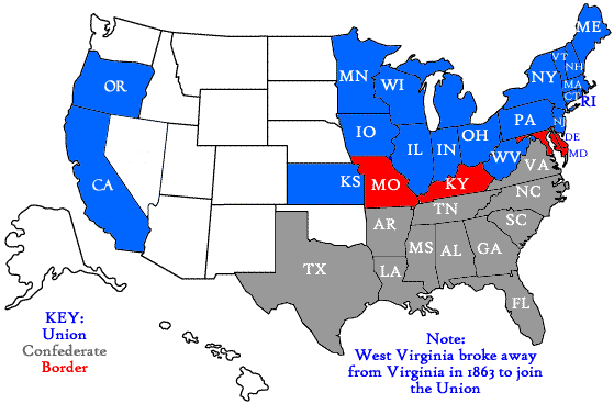
The Border States -- Delaware, Kentucky, Maryland, Missouri, and West Virginia -- comprised the Civil War's middle ground, a region of moderation lying
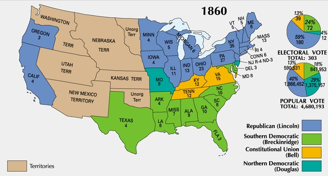
between the warring North and South. It was the region in which no states supported Abraham Lincoln in the 1860 presidential
election.
Yet, any hope that this pursuit of the middle ground would bring peace to
Border State residents was quickly dashed in wartime. Angry confrontations, including some of the most violent guerrilla warfare
in American history, became an everyday fact of life in this region, as the two sides lived side-by-side and confronted one
another on a daily basis. The Border States were both compromising in peacetime and antagonistic in war, two seemingly contradictory
positions that in fact sprung from the same source: each state encompassed deep and enduring internal divisions.
In the Border States, civilian loyalties were divided, with some favoring
secession and others remaining loyal to the Union. These divided populations had a profound impact
on Union and Confederate strategy, both political and military. Each side undertook measures, including brutal guerrilla
warfare, intended to persuade or sometimes conquer areas of divided loyalty. Each side suffered setbacks in the face
of hostile moral and political views held by local civilians.
In the Border States the war pitted neighbor against neighbor,
and the wrong word at the wrong time could land a civilian in jail. In some areas, bitter resentments and divisions remained
long after the war was over. See also Civil War Border States: A History.
| Union and Confederate Border State Civil War Map |
|
| Secession and Border State American Civil War Map Timeline |
Delaware was a border slave state that unanimously voted to stay in the
Union during the Civil War. Although Delaware is the second smallest state in the United States, its population was approximately
112,216 at the beginning of the war. Its size makes it a useful microcosm in understanding the divisiveness of the war.
Factionalism, from abolitionism to secessionism, existed in Delaware, but
many of its citizens did not align with either extreme. For example, there are three counties in Delaware. New Castle, which
contains the city of Wilmington, was a center of trade, industry, and Republicanism. The two other counties, Kent and Sussex,
were agricultural and generally pro-Southern. Thousands of men enlisted in the Union, but several hundred joined the
Confederacy. Communities were divided, and Union troops had to patrol election polls to protect Republican voters.
After the colonial period,the agricultural economy of the state began
to shift from tobacco to mixed farming, which created less need for slave labor. In 1860, there were 1,789 slaves in the state
and 19,829 free African Americans. Many slaves ran away during the war, and some elected to serve the Union. In 1863, 954
African Americans joined the Union army, and handful of others served in the navy. However, many citizens of this state were
not happy with the Emancipation Proclamation. In the 1864 election, they voted for George
B. McClellan, the Democratic candidate. After the war, Delaware Democrats rejected the 13th, 14th, and 15th Amendments and
worked to disenfranchise African Americans for several decades.
Although Delaware was not a battlefield, the war did find its way
into the First State. Fort Delaware became a prison for Confederate prisoners of war. The fortress was completed shortly before
the war began and is located on Pea Patch Island. The fort earned a reputation for cruelty and the moniker “Andersonville
of the North.” However, the death rate in Fort Delaware, which supported a prison population of over 30,000, was only
7.6%. Most northern prisoners had a rate of twenty-one percent. See also: Sectionalism and Causes of the American Civil War.
| Union, Confederate, Civil War Border States Map |
|
| Union, Confederate, Border State Civil War Strategy Map |
The Bluegrass State claims as native sons and daughters
many of the leading figures of the Civil War era, such as Abraham and Mary Todd Lincoln and Jefferson Davis. One of Kentucky’s
more prominent nineteenth century Senators, Henry Clay, spent much of his career trying to compromise the issue of slavery
before the war. His most well known efforts were in crafting the Missouri Compromise of 1820 and the later Compromise of 1850.
As clear from these most prominent residents, Kentucky was a state of divided loyalties and families torn apart. The state provided 90,000 troops
to the Union and 35,000 to the Confederacy. Nowhere was this division more evident than in the "First Family." Several members
of Mary Todd Lincoln's family fought for the South. Another family similarly divided was that of U.S. Senator John Crittenden,
whose two sons were generals on opposite sides. Some historians even say that the ensuing family feuds, such as the Hatfields
and the McCoys, carried on the war in Kentucky long after its official end.
| Civil War Border State Election Map Results |
|
| Civil War Border States and President Election Map Results |
In 1861, Kentucky’s governor, Beriah Magoffin, favored secession,
but the legislature voted to remain neutral. The major slaveholding areas in the Bluegrass Region and the western counties
favored the Confederacy and sent many recruits to its army. Early in the war, however, the Union entered Kentucky. By
the end of the Battle of Perryville in 1862, Confederate forces had retreated from the state. Although a rival secessionist
government was formed, it had little power. For the remainder of the war, Kentucky was the target of Confederate raids
by John Hunt Morgan, William Quantrill, Nathan Bedford Forrest and “Sue” Mundy. These raiders destroyed supply
lines, depots, public and private property.
When President Lincoln issued the Emancipation Proclamation in 1863,
it did not apply to Kentucky because it was a Border State. However, when he offered freedom to slaves who joined the Union
army, numerous slaves fled to Camp Nelson, Kentucky, which became a recruitment center and major fugitive slave camp. Although
the 13th amendment freed all slaves in 1865, the Kentucky General Assembly failed to ratify the 13th, 14th or 15th amendments
to the Constitution (each need to be ratified by ¾ of the states). As a symbolic gesture, the amendments
were officially ratified by the state on March 18, 1976. See also: Kentucky Civil War Border State: A History, States' Rights, and Civil War Border States History: HOMEPAGE.
Maryland was a Border State during the Civil War, divided between its status
as a slave state and its close ties to the nation’s capital. While Maryland stayed within the Union, it was mostly by
the strong hand of Abraham Lincoln. Maryland Governor Thomas Hicks, a Union sympathizer, refused to call the state legislature
during the secession crisis. He hoped that by remaining neutral the state could wait until passions had cooled.
However, there was considerable Confederate sympathy along the eastern shore, along the western shore of the Chesapeake
Bay south of the Susquehanna River, and along the Potomac River. On April 19, 1861, after Lincoln’s call for troops,
Confederate sympathizers attacked Union troops in Baltimore who were on their way to Washington DC. With more troops on the
way, Mayor Brown and Governor Hicks sent an order to burn the bridges north of town to avoid further confrontation.
The weeks following the Baltimore Riot of 1861were tense as troop lines
were reestablished. On April 27, President Lincoln authorized the suspension of the writ of habeas corpus in Maryland, if
public safety demanded it. Lincoln ordered the military to arrest several Confederate sympathizers and hold them as political
prisoners. John Merryman was among those incarcerated at Fort McHenry. When Merryman appealed for his release, Chief Justice
Roger Taney, in ex parte Merryman, ruled that the Constitution permitted only Congress to suspend the writ. This debate on
civil liberties only served to further galvanize citizens of Maryland against Union occupation.
| Civil War Border State Map |
|
| Civil War Border States Map |
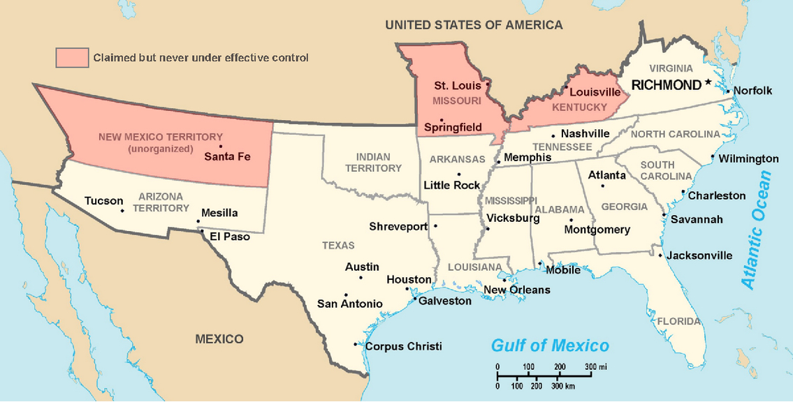
(Map) Historic Southern United States: A Controversial Border State Map.
The Confederate States have historically been regarded as forming "the South." States shown in light red are considered "border
states" and "border areas," and gave varying degrees of support to the Southern cause although they remained in the Union.
(This image depicts the original, trans-Allegheny borders of Virginia, and so does not show West Virginia separately. See
the images above for post-1863 Virginia and West Virginia borders.) Although Oklahoma was aligned with the Confederacy, it
was not an official state because at the time the region was Indian Territory (also known as "IT"), not a state. The map,
furthermore, does not reflect Maryland and Delaware because, according to some historians, they had a lesser degree of
support, control and alignment with the South and Confederacy. Today, however, according to the US Census Bureau,
Maryland, Delaware, West Virginia and Kentucky are considered Southern states, while Missouri is considered a Midwest
state. See also Mason-Dixon Line and the Border States.
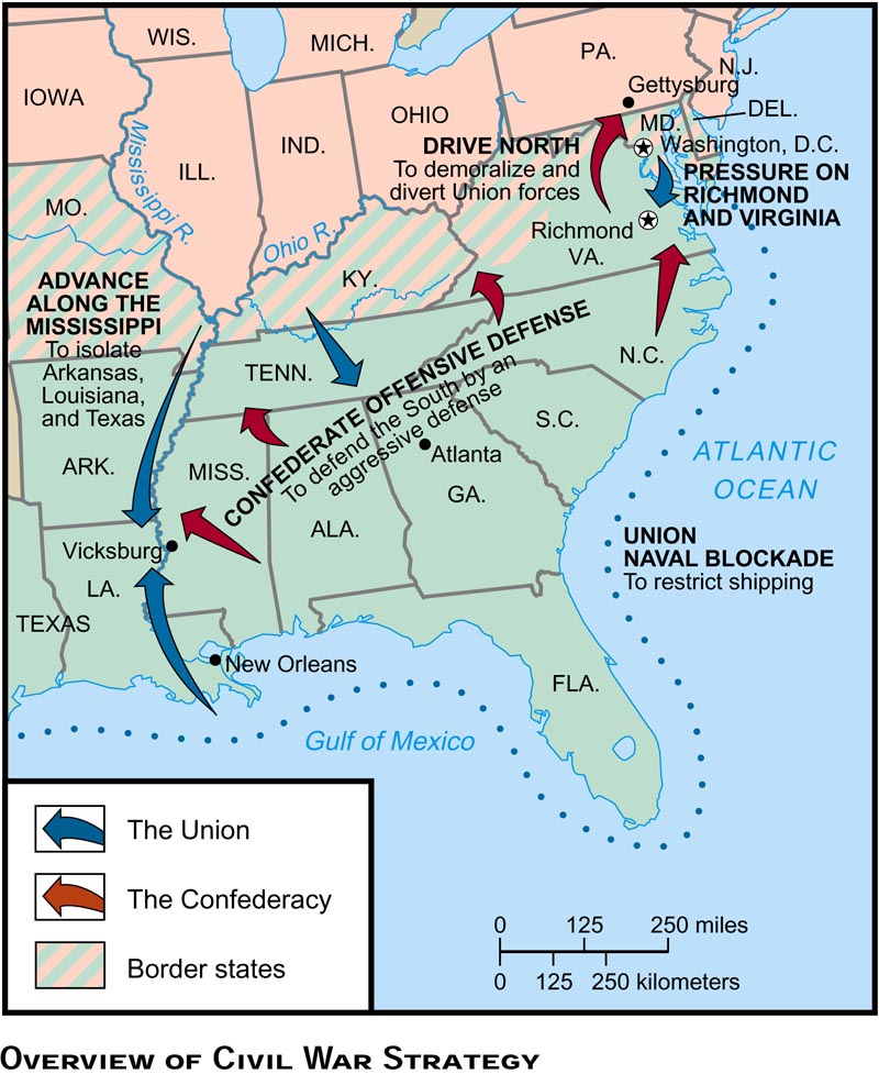
After General Robert E. Lee’s success at the Second Battle of Manassas in 1862, he looked to take
the war out of Virginia and into the North. He hoped such an invasion would bring Maryland back to the South, influence midterm
elections, and perhaps end the war. In a bold move, Lee split his army upon crossing the Potomac River. Half of the army led
by General Thomas “Stonewall” Jackson went to capture Harpers Ferry. The other half moved towards Frederick, Maryland,
where they engaged General George McClellan’s Union troops in the Battle of South Mountain. Jackson was successful in
capturing Harpers Ferry, but Lee was forced to retreat. He decided to make a stand at Antietam Creek near Sharpsburg on September
17, 1862. The Battle of Antietam was the bloodiest one day battle in American history, with approximately 23,000 casualties.
Lee was forced to retreat back to Virginia. The Union’s victory led Lincoln to issue a preliminary emancipation proclamation,
thus incorporating the abolition of slavery into the North’s war aims. The Confederacy did not achieve any of its aims
in Maryland, and it lost an opportunity for international recognition and aid.
Support for the Union in Maryland seemed to increase in 1863. The state
was no longer the battleground that it was in 1862. The citizens began to enjoy the prosperity of supporting the Union army.
This strengthening of Union sentiments led the state legislature to renew their discussion of the abolition of slavery. Slave
valuations had disintegrated and many slaves had joined the Union army. In 1864, by a narrow margin of 375 votes, the state
adopted a new constitution that abolished slavery. See also Maryland Civil War Border State: A History, Secession, Border States, and Civil War, and Civil War Border States History: HOMEPAGE.
| Border State Map |
|
| Border States Map |
In 1820, Missouri gained national attention as the
focus of the Missouri Compromise. It was the northernmost slave state in the Mississippi River valley, and when its neighbor
Kansas wanted to enter the Union in 1854 as a free state, trouble erupted along the border.
Missouri Compromise of 1820: The admission of Missouri as a state in 1820
provoked a contentious national debate over slavery. Missouri was the second state to be carved from the vast territory acquired
from France in the Louisiana Purchase and was to be admitted as a slave state. This aroused concern in the North. After much
wrangling, a compromise was worked out. Under the terms of the Missouri Compromise, Maine was admitted as a free state at
the same time that Missouri came in as a slave state, maintaining the balance between slave and free states. Additionally,
Congress prohibited slavery in all western territories lying above 36° 30' latitude (the southern boundary of Missouri).
Compromise of 1850: As a result of the Mexican War (1846-1848), the United
States won vast acreage in the West (present-day California, Arizona, New Mexico, Nevada, Utah, and parts of Colorado and
Texas). This acquisition renewed the controversy over slavery in the territories. California applied for admission as a free
state in 1850. Southern political leaders were concerned that this would upset the balance of 15 free and 15 slave states.
They also were disturbed by northern agitation to end slavery in the District of Columbia and by the passage of "personal
liberty" laws in the northern states. The personal liberty laws aimed to restrict the cooperation of state officials in enforcing
the federal fugitive slave law. Southern senators blocked the admission of California and a crisis was at hand. Prolonged
negotiation finally produced a series of measures that became known as the Compromise of 1850. Aspects of the compromise included
1) admission of California as a free state; 2) a stronger fugitive slave law; 3) assurance that Congress would not interfere
with the interstate traffic in slaves in the South; and 4) prohibition of the slave trade in the District of Columbia. Finally,
an act allowed the citizens of the remaining territories to be carved out of former Mexican land to decide for themselves
on allowing slavery. Optimists believed that these measures constituted a lasting settlement of the divisive issue of slavery,
but this was not to be.
Kansas-Nebraska Act: In 1853-1854, the slavery issue got tied up with the
effort to build a transcontinental railroad. In order to achieve territorial organization of land that a railroad to the West
Coast might pass through, the Democratic Party had to make concessions to the South. The Kansas-Nebraska Act of 1854 gave
the people of those territories the authority to decide on the legal status of slavery, effectively repealing the Missouri
Compromise line. This act kicked off seven years of intense national dispute over slavery, culminating in secession and, finally,
civil war in 1861. Northerners were outraged at the Kansas-Nebraska Act's repeal of a long-established compromise. Pro- and
anti-slavery factions immediately converted the territory of Kansas into a bloody battleground.
Border Wars: The years of 1854-1861 were a turbulent time in Kansas territory.
The Kansas-Nebraska Act of 1854 established the territorial boundaries of Kansas and Nebraska and opened the land to legal
settlement. It allowed the residents of these territories to decide by popular vote whether their state would be free or slave.
This concept of self-determination was called "popular sovereignty." In Kansas, people on all sides of this controversial
issue flooded the territory, trying to influence the vote in their favor. Rival territorial governments, election fraud, and
squabbles over land claims all contributed to the violence of this era.
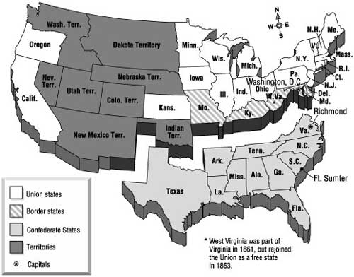
| United States in 1860 Map |
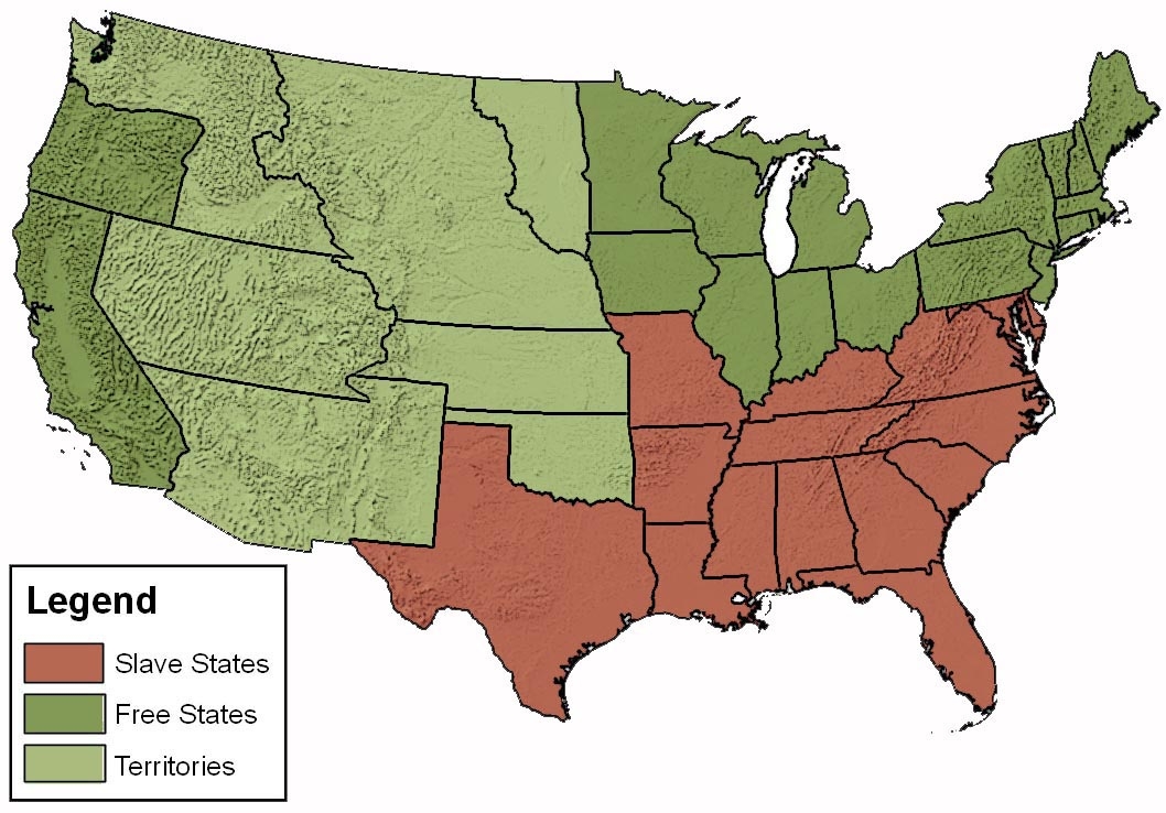
|
| Border States, Free States, Slave States, and Territories Map |
Three distinct political groups occupied neighboring Kansas: pro-slavers,
free-staters and abolitionists. Violence broke out immediately between these opposing factions and continued until January
29,1861, when Kansas entered the Union as a free state. This era became forever known in the state as "Bleeding Kansas."
As Missourians tried to influence internal politics in Kansas, random violence
became commonplace. Missouri guerrillas and Kansas jayhawkers raided and killed at will. A major event in during this time
period was the Dred Scott Supreme Court decision in 1857, which not only denied the slave Dred Scott and his wife their freedom,
but went on to declare that African Americans per se were not citizens under the Constitution. Scott and his wife had
filed their first petitions in the courthouse in St. Louis, Missouri.
The outbreak of the Civil War in 1861 would legitimize the killing that
had plagued Missouri for years. Union General Nathaniel Lyon, an ardent abolitionist, commanded all Union troops in the state.
Former governor Sterling "Pap" Price became the commander of the pro-secession Missouri
State Guard. The two sides met at Wilson's Creek in August of 1861. Lyon boldly attacked the Missouri State Guard that had
been joined by a larger Confederate force, and even though he lost the battle and his life, he succeeded in keeping the state
under Union control.
Although Missouri remained under Union control for the rest of the war,
as a Border State, it provided troops to both sides, pitting neighbor against neighbor, brother against brother, and father
against son. Guerrilla warfare reigned over the state for the remainder of the war, during which time William
Quantrill, Bloody Bill Anderson, and Frank and Jesse James began their infamous careers. A unified Confederate force was not
seen in Missouri again until late 1864, when Sterling Price failed in a desperate attempt to regain control of the state.
Legend has it that every general on both sides of the Civil War served at
Jefferson Barracks at one time. Among those who did are Jefferson Davis, Robert E. Lee, Ulysses S. Grant, and William Tecumseh
Sherman. During the war, Jefferson Barracks had one of the largest Federal hospitals
in the country, with over 3,000 beds, accommodating patients from battles as far away as Vicksburg. The Jefferson Barracks
Historical Park exhibits photos, medical equipment, uniforms and weapons housed in buildings that were used during the Civil
War. Among the Civil War veterans buried in the Jefferson Barracks National Cemetery are 1,140 Confederates. See also: Missouri Civil War Border State: A History, Causes of the American Civil War, and Civil War Border States History: HOMEPAGE.
| Border State Reconstruction Map |
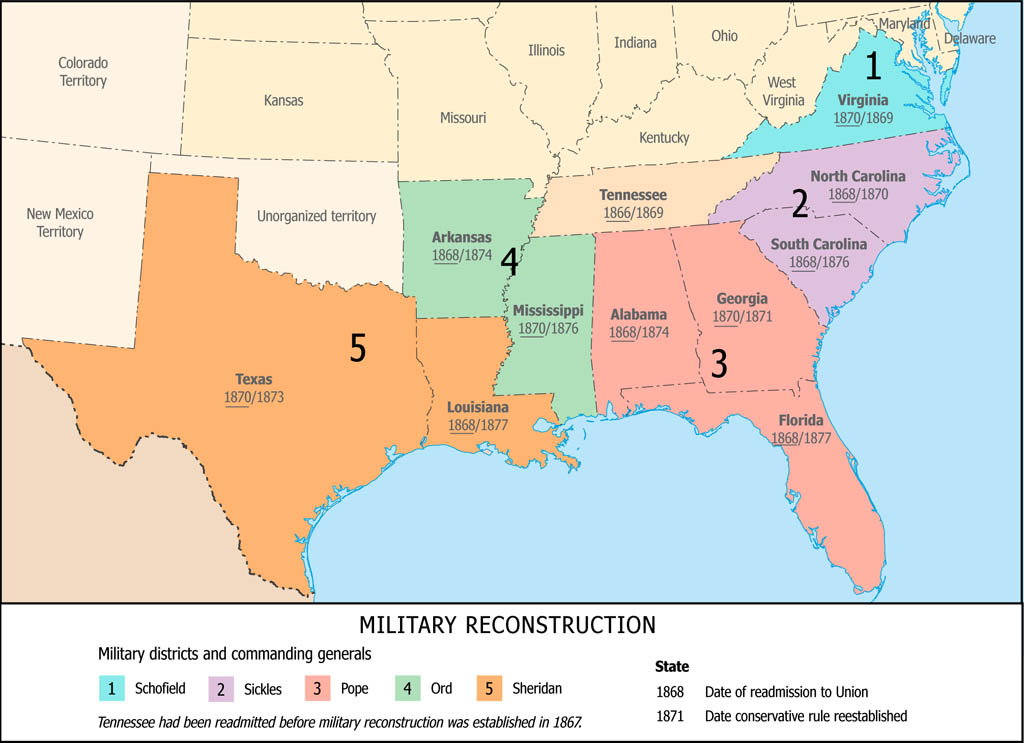
|
| Civil War Border States Reconstruction Map |
The Mountain State entered the Union on June 20, 1863.
Forming the western region of Virginia, West Virginia severed its ties from Virginia, and was only one of two states
created during the Civil War (the other being Nevada). Not only did it incur revolutionary political changes, but it was the
scene of several national events. The first shots of the impending war were fired on the night of October 16, 1859. Abolitionist
John Brown led an armed band of twenty-one men to Harpers Ferry, a strategic location on the confluence of the Potomac and
Shenandoah Rivers near Washington, D.C. (known as Washington City at the time). Brown and his men captured the federal armory,
arsenal, and Hall’s Rifle Works. His men held sixty citizens as hostages in hopes of persuading their slaves to join
them, but no slaves came forward. President Buchanan sent the federal militia to put an end to the raid. The state of Virginia
charged Brown with treason. Southerners condemned the raid, while militant abolitionists proclaimed him a martyr.
Western Virginians were acutely aware of the divisiveness of the Civil
War. When the Richmond Convention decided to secede from the Union in April 1861, northwestern delegates immediately returned
to their home counties to drum up Union support before Virginians voted on the Ordinance. John S. Carlile, an influential
politician and powerful orator, called for the formation of a new state at this First Wheeling Convention, but other delegates
believed such an act was illegal, since this act required the permission of the older state.
When the Secession Ordinance was approved in May, a Second Wheeling
Convention was called. The delegates formed the Reorganized Government of Virginia based in Wheeling. They elected a new Virginia
governor (Francis Pierpont) and appointed new Virginia Senators (John Carlile and Arthur Boreman). Delegates were divided
and argued throughout the whole process, debating the state’s size and the issue of slavery. Carlile was asked to draft
a report on West Virginia statehood. As a conservative dismayed with the radical Congress, he tried to sabotage the bill.
Boreman managed to save it with the addition of the Willey Amendment, which provided for emancipation. The bill was approved
by Congress, but President Lincoln questioned the legality before he finally signed the bill December 31, 1862. It went back
to the voters, who approved the amended bill. West Virginia became the 35th state on June 20, 1863.
| Present-day US Census Bureau Border States Map |

|
| Present-day Census Bureau Border State Map |
The Union Army facilitated these revolutionary political changes when
it achieved control of northwestern Virginia early in the war. The army was able to retain control through engagements in
Philippi, Rich Mountain, and Carnifex Ferry. In 1862, Clarksburg native Thomas “Stonewall” Jackson swept through
on his Shenandoah Valley campaign, resulting in skirmishes in the Eastern Panhandle. Despite general Union control, this did
not mean West Virginians were safe from
confederate raiders. Guerrilla warfare persisted after 1863 until the end of the war, including the Jones-Imboden Raid, Battle
of Droop Mountain, and raids by McNeill’s Rangers of Hardy County.
(Sources and related reading below.)
Sources: National Park Service; Library of Congress; National Archives;
Official Records of the Union and Confederate Armies.
|
