|
Civil War on Roanoke Island
Battle of Roanoke Island, North Carolina
Battle of Roanoke Island
Other Names: Fort Huger
Location: Dare County
Campaign: Burnside's North Carolina Expedition (February-June 1862)
Date(s): February 7-8, 1862
Principal Commanders: Brig. Gen. Ambrose E. Burnside [US]; Brig.
Gen. Henry Wise [CS]
Forces Engaged: 10,500 total (US 7,500; CS 3,000)
Estimated Casualties: 2,907 total (US 37K/214W/13M; CS 23K/58W/62M/2,500
Captured)
Summary: On February 7, Brig. Gen. Ambrose E. Burnside,
during Burnside's North Carolina Expedition, landed 7,500 men on the southwestern side of Roanoke Island in an amphibious operation launched from Fort Monroe. The next
morning, supported by gunboats, the Federals assaulted the Confederate forts on
the narrow waist of the island, driving back and out-maneuvering Brig. Gen. Henry Wise’s outnumbered command. After
losing less than 100 men, the Confederate commander on the field, Col. H. M. Shaw, surrendered about 2,500 soldiers and 32
guns. With this important outpost on the Atlantic Coast, Burnside had tightened the Federal blockade and accomplished
a strategic objective in Gen. Winfield Scott's Anaconda Plan. (See also Battle of Roanoke Island: A History.)
By late spring 1862, Union soldiers occupied Hatteras Inlet and controlled the towns of Plymouth, Washington and New Bern. The loss of most of the North Carolina coast and coastal waterways
was a blow both to Confederate morale and the young nation's ability to supply its armies in the field. But aside from
a few raids from those bases, the Union forces didn't advance until Sherman entered North Carolina in March-April 1865, in
what was commonly referred to as Sherman's March.
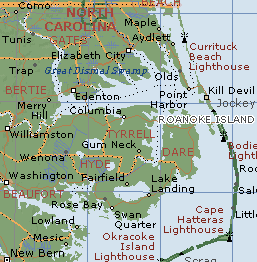
| Civil War Roanoke Island, NC |
|
| (Courtesy Microsoft MapPoint) |
| Civil War Roanoke Island Map |

|
| Battle of Roanoke Island, NC. Courtesy NASA. |
| Battle of Roanoke Island Map |
|
| Civil War Battle Roanoke Island |
Analysis: Union forces set their sights on Roanoke
Island, the linchpin in North Carolina’s coast, in early 1862. It was vital for Confederates to hold the island. If
the Confederates lost Roanoke Island, it would only be a matter of time before Albemarle Sound, its port cities, and backdoor
access to Norfolk would also be lost to the Union. Losing Roanoke Island would mean losing all of eastern North Carolina.
Brigadier General Henry Wise, the Confederate commander on Roanoke Island, had no formal military training, but he recognized
his vulnerable situation, pleading for reinforcements, but never receiving them.
Only one road ran north to south along the length of the island. Confederate
troops built fortified earthworks on the road at the center of the island to defend against a land-based assault. Confederates
also constructed forts on the northwest coast of the island, enabling cover of a water-based
assault from the west. Union ships with their longer guns, came from the south, but remained easily out of range of all but
the southernmost fort, which they quickly disabled.
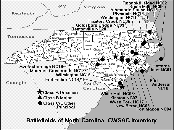
(Right) Map of North Carolina battlefields. Although the National Park Service
has identified 20 principal Civil War battlefields in the Old North State, it concedes that additional fields of battle exist
within Old Carolina.
Late in the afternoon of February
7, 1862, Union troops under Brigadier General Ambrose Burnside landed with the aim of assaulting the earthworks and
road at the center of the island. The soldiers quickly captured the landing site and spent a wet night before the battle.
At dawn the Union troops successfully pushed through thick marshes to fire on the flanks of the earthworks while others attacked
from the front. The Confederate troops were overwhelmed, fleeing to the north end of the island, where they ultimately surrendered
Roanoke Island to the Union.
The fall of Roanoke Island opened eastern North Carolina to Union control.
By the summer of 1862, the port cities of Plymouth, Elizabeth City, New Bern, Washington, Edenton, Hertford, N.C., and Norfolk,
VA., had all fallen to Union forces. The vital rail line carrying supplies from Wilmington—North Carolina’s only
remaining Confederate port—was also vulnerable. With the huge success at Roanoke Island, the Union stranglehold on the
South was ever tightening.
Sources: National Park Service; Microsoft Map; NASA Map.
Recommended Reading: The
Civil War on Roanoke Island North Carolina: Portrait of
the Past (Hardcover). Description: Even
though the Civil War on Hatteras Island ended with the capture of Hatteras by Union forces,
the Outer Banks role in the war continued. Brigadier General Ambrose Burnside continued his expedition into Roanoke Island
in 1862, along with flag officer L. J. Goldsborough, Colonel Rush Hawkins of the Ninth New York Zouaves, and many others,
causing great upheaval and dissonance to the simple lives of the islanders. Continued below...
The pictures
can almost tell the story, but the rich historical detail in the text is absolutely fascinating. This book features drawings
by James Wells Champney, who was also stationed at Fort Macon
in the Outer Banks with the Union forces. In addition, journal entries and personal correspondence of soldiers such as Charles
F. Johnson and Capt. William Chase (of the 4th Rhode Island)
and the development of freedom's colony allow the reader a truly personal look into the soldiers' lives during these trying
times.
Recommended Reading:
The Civil War on the Outer Banks: A History of the Late Rebellion Along the Coast of
North Carolina from Carteret to Currituck With Comments on Prewar Conditions and an Account of (251 pages). Description: The ports at Beaufort, Wilmington, New Bern and Ocracoke, part
of the Outer Banks (a chain of barrier islands that sweeps down the North Carolina coast from the Virginia Capes to Oregon
Inlet), were strategically vital for the import of war materiel and the export of cash producing crops. Continued below...
From official records, contemporary newspaper accounts, personal journals of the soldiers, and many unpublished
manuscripts and memoirs, this is a full accounting of the Civil War along the
North Carolina coast.
Recommended Reading:
The Civil War in Coastal North Carolina (175 pages) (North Carolina Division
of Archives and History). Description: From the drama
of blockade-running to graphic descriptions of battles on the state's islands and sounds, this book portrays the explosive
events that took place in North Carolina's coastal region during the Civil War. Topics discussed include the strategic
importance of coastal North Carolina, Federal occupation
of coastal areas, blockade-running, and the impact of war on civilians along the Tar Heel coast.
Recommended Reading: Ironclads and Columbiads: The Coast (The Civil War in North Carolina)
(456 pages). Description: Ironclads and Columbiads
covers some of the most important battles and campaigns in the state. In January 1862, Union forces began in earnest to occupy
crucial points on the North Carolina coast. Within six months,
Union army and naval forces effectively controlled coastal North Carolina from the Virginia line south to present-day Morehead
City. Continued below...
Union setbacks in Virginia, however, led to the withdrawal of many federal soldiers from North Carolina,
leaving only enough Union troops to hold a few coastal strongholds—the vital ports and railroad junctions. The South
during the Civil War, moreover, hotly contested the North’s ability to maintain its grip on these key coastal strongholds.
Recommended Reading: Storm over Carolina: The Confederate
Navy's Struggle for Eastern North Carolina. Description: The struggle for control of the eastern waters of North Carolina during the War Between the States was a bitter, painful,
and sometimes humiliating one for the Confederate navy. No better example exists of the classic adage, "Too little, too late." Burdened
by the lack of adequate warships, construction facilities, and even ammunition, the South's naval arm fought bravely and even
recklessly to stem the tide of the Federal invasion of North Carolina from the raging Atlantic. Storm Over Carolina is the account of the
Southern navy's struggle in North Carolina waters and it
is a saga of crushing defeats interspersed with moments of brilliant and even spectacular victories. It is also the story
of dogged Southern determination and incredible perseverance in the face of overwhelming odds. Continued below...
For most of
the Civil War, the navigable portions of the Roanoke, Tar, Neuse, Chowan, and Pasquotank rivers were
occupied by Federal forces. The Albemarle and Pamlico sounds, as well as most of the coastal towns and counties, were also
under Union control. With the building of the river ironclads, the Confederate navy at last could strike a telling blow against
the invaders, but they were slowly overtaken by events elsewhere. With the war grinding to a close, the last Confederate vessel
in North Carolina waters was destroyed. William T. Sherman
was approaching from the south, Wilmington was lost, and the
Confederacy reeled as if from a mortal blow. For the Confederate navy, and even more so for the besieged citizens of eastern
North Carolina, these were stormy days indeed. Storm Over Carolina describes their story, their struggle, their history.
Try the Search Engine for Related Studies: Complete list of all North Carolina Civil War Battles, Battlefields,
History Maps, Results, North Carolina Civil War Forts, Facts, Structures, Photos, Photographs, Pictures, North Carolina Expedition
Battles.
|